How high is the water near you? Check out Floodzilla.com for forecast information, real-time flood elevations in the lower Valley, and contemporary historical flood data collected by Floodzilla. For help using this powerful tool, contact your Floodzilla Field Scientist at regina@svpa.us. During flood events, the gages are updating every 15 minutes.
 The SVPA has developed a citizen-science tool to make it easier to track what’s happening while it’s happening, and also to collect data to gain insight on how flooding is changing.
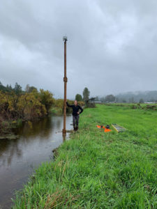
A team of dedicated members of the valley community, led by original Floodzilla author Geary Eppley, has deployed remote sensing flood gages. The flood gauges, placed near roads, on bridges, and in fields throughout the Valley, measure the height of the water level every 15 minutes. This height is sent to our website where it is configured to let Valley residents and visitors know the real-time elevation of flood water. Visit our flood network website to see the gages currently up and running. Do you know of a road or area that needs a gauge? Let us know! The SVPA is able to provide this vital community tool with grant funding support from the King County Flood Control District over past 5 years. Thank you King County Flood Control District!
About the Floodzilla Gauge Network
The Snoqualmie Valley Preservation Alliance’s (SVPA) Floodzilla Gauge Network monitors water levels throughout the Snoqualmie Valley, in real-time. This flood monitoring network is the innovation of a group of local technology professionals who have volunteered their time and expertise to develop this tool for the benefit of the community. Paid staff and consultants have also contributed to the project with funding through SVPA’s generous donors and with a grant from King County Flood Control District.
The Floodzilla Gauge Network relies on a series of SVPA gauges placed in strategic locations to monitor water levels in drainage ditches, farm fields, on public roads, and on the Mainstem Snoqualmie River. The SVPA gauges are ultrasonic sensors that have been programmed to read and transmit water level data every 15 minutes during flood season, from October through May.
While the USGS gauges have provided reliable Snoqualmie River water level data to valley residents for decades, there is only one gauge on a 30-mile stretch of river between the USGS Snoqualmie Falls gauge at river mile (RM) 40, and the USGS Duvall gauge at RM 10. During flood events, there can be a significant, and unpredictable lag between the timing of upstream flooding in the Fall City/Carnation area and flooding further downstream near Duvall. The SVPA Floodzilla Gauge Network fills in this data gap with gauges on the river and in nearby farm fields and ditches, giving the farmers, residents, and commuters vastly more information to prepare.
Flood impacts to local roads is of significant importance to farmers, residents, and commuters. Most roads that go under during flooding do not flood as a result of overbank flooding from the river, but instead, from inundation of adjacent ditches or fields. The SVPA Floodzilla Gauge Network monitors water levels not only in the river, but also to provide information to the public whether or not there is water on a particular road, as well as how deep it is. This is helpful when roads are not flooding yet, as they show height of the water relative to the spot where the road first goes under.
We hope you find this information useful! If you have any questions about the SVPA’s Floodzilla Gauge Network, please contact us at info@svpa.us or call the office at 425-549-0316. Regina Fletcher regina@svpa.us is the Field Scientist for this project.
Inundation Mapping and Data Accuracy Algorithm
Over the course of the 2022-2023 academic year, a Seattle University Senior Design team, composed of Jamie Elrod, Ruby Hooper, Sean Tachibana, Owen Trampe, and supervised by Dr. Lee, worked with SVPA and the Floodzilla Gauge Network Team to developed an automated and efficient screening algorithm to improve data accuracy displayed to users as well as developed an approach to display inundation maps on the Floodzilla website. These inundation, or flood, maps expand the accessibility of flood-related information to the public and the screening algorithm greatly reduces the need for manually removing erroneous data from SVPA-operated gauges.
The Senior Design teams accomplishments with this project led them to achieving first place in both the Environmental and Water-Related Issues’s annual WSP student Design Competition held in Nevada and the Annual American Society of Civil Engineers competition held in Seattle.
To view their final report, click HERE.
Meet the Floodzilla Team!
Geary Eppley
Floodzilla Creator and Project Manager
Regina Fletcher
Floodzilla Field Scientist
Dave Sanderman
Software Engineer
Pavlo Babenko
Software Engineer
Dean Vergillo
Structure Design and Installation Specialist

The Floodzilla Gauge Network is the product of community collaboration and innovation. Program Creator and Manager, Geary Eppley, has volunteered countless hours over many years to developing this tool for the Snoqualmie Valley Community. He works side by side with SVPA staff, contractors, and other volunteers to continue managing and enhancing this important resource. Our Floodzilla Software Engineers as well as our Gauge Structure Design and Installation Specialist provide their services to us significantly below market rate and often donate many hours of work entirely in-kind as they are dedicated to ensuring Floodzilla remains an accessible and useful tool for Snoqualmie Valley residents, businesses, visitors, and land managers.
The community support doesn’t stop here though… we also partner with private landowners and local government to host our gauges on site as well as our network connectivity equipment. Our data stewards and gage stewards play a very important volunteer role in helping our staff maintain gage sites and ensure the most accurate data is displayed on the Floodzilla website.
We can never thank all these incredible individuals enough for everything they do to keep Floodzilla up and running and accessible to all of us in the valley.